Are the 3 'clusters' (see (1) Alabama Rot UK Map) of confirmed cases of Alabama Rot around Greater Manchester, New Forest and Guildford indicative of an Alabama Rot causing environmental factor at a higher concentration relative to other non-cluster areas of England?
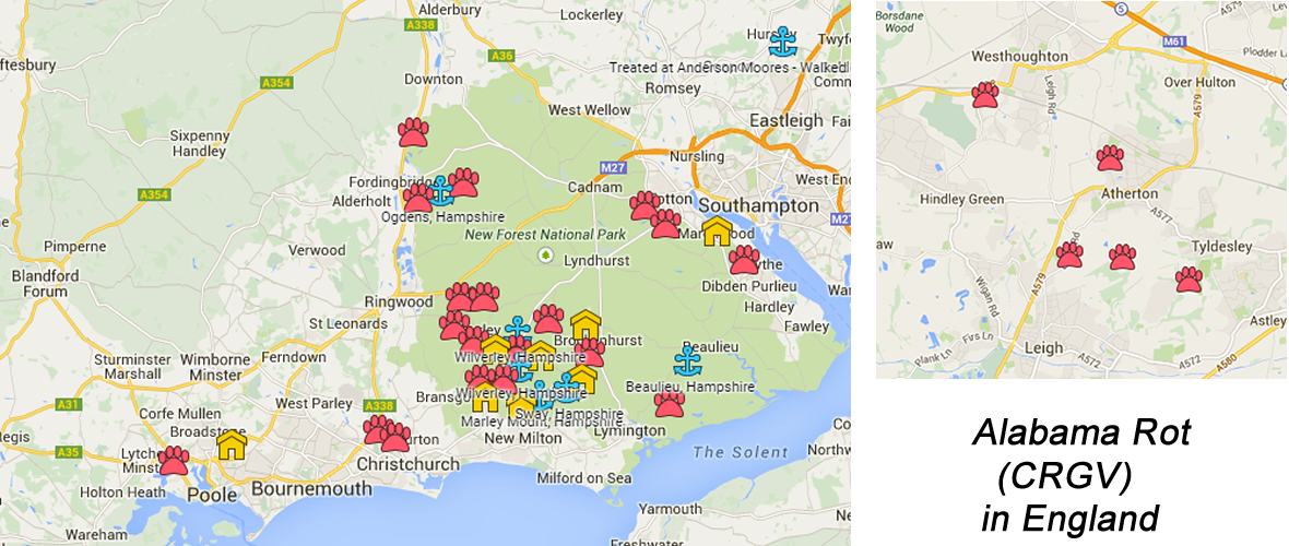
There have been 47 confirmed cases (the red paws in the maps below) of Alabama Rot in England between December 2012 and 25th January 2015.
Greater Manchester has a cluster of 6 cases in approx. 122km2 area or 1 case per 21km2 (using the Google map area measurement tool)
 |
| Greater Manchester has a cluster of 6 cases in approx. 122km2 area or 1 case per 21 km2 |
 |
| The New Forest has a cluster of 16 cases in approx. 378km2 area or 1 case per 24 km2 |
 |
| Guildford has a cluster of 4 cases in approx. 93km2 or 1 case per 23km2. |
Adding up all 3 clusters (New Forest, Greater Manchester and Guildford), 26 cases occur in 593 km2 or average 1 case per 23 km2.
 |
| Area that bounds all English cases is approx. 97,663 km2. |
The 21 cases (47 total less 26 in clusters) not occurring in clusters are spread over an area of 97,070 km2 (97,663-593 km2) or 1 case per 4622 km2.
Therefore dogs walked in the 3 cluster areas (Greater Manchester, New Forest and Guildford) seem to be at x200 (4622/23) greater risk of dying from confirmed Alabama Rot than dogs walked in non-cluster Alabama Rot areas.
But are these 3 clusters statistical flukes? What is likelihood that these clusters could occur by chance?
References
(1) Alabama Rot UK Map: https://www.google.com/maps/d/edit?mid=zIJgTtl9x6zk.kif7awTR9hAA
No comments:
Post a Comment